Task ID: O-0205
(31-Jan-01) |
LOCATE A POINT ON A MAP USING THE CAP GRID SYSTEM |
|---|
CONDITIONS
Given an aeronautical chart, road map, or topographical map gridded with the CAP grid system. You are away
from mission base, mounted or dismounted, and must plot your location on a CAP gridded map in order to
report it, an aircraft or another ground element. Or, you are coordinating with another search element (ground
or air) who has told you his location using the CAP grid system. You want to plot this point on your map.
OBJECTIVE
Within 1 minute, the team member announces the CAP grid and sub-grid that the point is located in, using
correct terminology, and can plot a point on the map given the CAP grid coordinates orally.
TRAINING AND EVALUATION
Training Outline
- The CAP grid system is designed for use on aeronautical charts, but can be adapted to any map with
latitude/longitude markings around the edge.
- A grid is a 15 minute latitude by 15 minute longitude box. This is done by dividing the 30 minute by 30
minute boxes already on the aeronautical chart into fourths. Each grid is identified with a number. (For
example "I am located in Grid 54").
- To locate a position more precisely, mentally divide each grid into four quadrants. The Northwest quadrant
is "A", the Northeast is "B", the Southwest is "C", and the Southeast is "D". Say the quadrant letter after the
grid number (for example, "I am in grid 54 B").
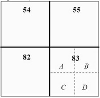 Example of CAP grids (54,55,82 and 83) and lettered quadrants (83A, 83B, 83C, and 83D)
- To find the grid designation of a known point on the map
- Find the grid number the point is in.
- Determine which quadrant of the grid the point is in (A, B, C, or D)
- To plot a point given a grid number and quadrant letter:
- Find the appropriate grid on the map (the grid numbers increase as you look left to right and top to
bottom on the map.
- Mark the point in the appropriate lettered quadrant of that grid.
Additional Information
More detailed information on this topic is available in Chapter 5 and Attachment D of the Ground Team Member & Leader Reference Guide.
Evaluation Preparation
Setup:
Mark a point on a CAP gridded map or chart and give the map to the student. Pick a different grid
location from the point and write down the grid and quadrant. Ensure you have a timer.
Brief Student:
Tell the student to tell you the CAP grid and quadrant designation of the point. Then orally
give him the grid and quadrant of the point you wrote down and tell him to show you where that point is on the
map.
Evaluation
| Performance measures | Results |
| The individual determines the grid of a known point: | |
| 1. Announces the correct grid number and quadrant within 1 minute | Pass | Fail |
| The individual determines the location of a designated grid: | |
| 1. Finds the correct numbered grid and quadrant within 1 minute | Pass | Fail |
Student must receive a pass on all performance measures to qualify in this task. If the individual fails any measure, show what was done wrong and how to do it correctly.
Based on CAP SQTR Reference